News on an upcoming conference called Mobilefest. According to press:
'MOBILEFEST is the First International Festival of Mobile Art and Creativity, will take place in September, in São Paulo, Brazil. In its first edition, it aims to discuss the sociological, cultural and esthetics implications that mobile phones and their technologies have been promoting globally. In fact, the global transformations the world has been gone through have modified the way we realize, interpret and represent reality.
The theme of the event is: How can Mobile Technology contribute to democracy, culture, art, ecology, peace, education, health and third- sector? Submissions are open until July 31 for paper and presentation proposals: details here.'
Does sound interesting...
Saturday, July 22, 2006


Howard Rheingold Interview
ZDNet has an interview with Howard Rheingold titled 'Howard Rheingold about our mobile world' - short yet worth a read: never a waste of a few minutes!
Catholic Mobile
A recent post from Smartmobs looks mobile technologies and the Catholic church:
"The Vatican and the Catholic church have in been on the front edge of new technologies since the very beginning of the Internet and wireless messaging. Now a new Website, Catholic Mobile, is a new and comprehensive offer to provide families and individuals with inspiring Catholic content in English and Spanish
Catholic Mobile users can receive messages by subscribing or selecting from a range of services anytime, anywhere, from their cell phones, PDA's or smart phones. Using a text messaging service, daily prayers, the saint of the day, or daily scripture readings will be sent directly to the individual's cell phone or mobile device.
Users will also be able to personalize their phones by downloading Catholic wallpapers and ringtones."
"The Vatican and the Catholic church have in been on the front edge of new technologies since the very beginning of the Internet and wireless messaging. Now a new Website, Catholic Mobile, is a new and comprehensive offer to provide families and individuals with inspiring Catholic content in English and Spanish
Catholic Mobile users can receive messages by subscribing or selecting from a range of services anytime, anywhere, from their cell phones, PDA's or smart phones. Using a text messaging service, daily prayers, the saint of the day, or daily scripture readings will be sent directly to the individual's cell phone or mobile device.
Users will also be able to personalize their phones by downloading Catholic wallpapers and ringtones."
Swarm Intelligence and Traffic Safety
CalTech is working on research into 'Swarm Intelligence and Traffic Safety'
Abstract. A smart car that assists the driver must give warnings in dangerous situations, override the driver to avoid collisions, and help to reach the intended destination as quickly as possible. Unfortunately, satisfying these requirements and at the same time leaving the decisional autonomy at the individual level becomes an extremely hard problem to solve with traditional methods. Biologically-inspired techniques such as Swarm Intelligence and Incremental Evolution provide new promising ways to tackle the design and distributed control problems of a traffic system. In this project, solutions are developed using embodied simulations and validated with real robot experiments.
The site has some photos and further explanations.
Abstract. A smart car that assists the driver must give warnings in dangerous situations, override the driver to avoid collisions, and help to reach the intended destination as quickly as possible. Unfortunately, satisfying these requirements and at the same time leaving the decisional autonomy at the individual level becomes an extremely hard problem to solve with traditional methods. Biologically-inspired techniques such as Swarm Intelligence and Incremental Evolution provide new promising ways to tackle the design and distributed control problems of a traffic system. In this project, solutions are developed using embodied simulations and validated with real robot experiments.
The site has some photos and further explanations.
RFID Resources
The Institute for the Future (IFTF) has published some pdf reports on RFID use:
SR-926A
Thinking About RFID
SR-926B
Public Concerns and the Near Future of RFID
SR-926E
RFID: Implications and Recommendations
Very useful - thanks to IFTF!
SR-926A
Thinking About RFID
SR-926B
Public Concerns and the Near Future of RFID
SR-926E
RFID: Implications and Recommendations
Very useful - thanks to IFTF!
Israel - Lebanon Maps
Cartography has a post that looks at some of the recent , and inevitable, maps that are appearing on media sites that show the sites of violence in the Middle East at present:
'Maps of the current violence in the Middle East between Israel and Hezbollah are appearing everywhere. The usual news sources have their set of graphics and maps that outline the events in different ways. The Guardian has an animated Flash map which steps through the various incidents that has led up to the current state of affairs, including a day by day summary that is current to the 20th. The map shows Hezobollah and Israeli attacks and also the approximate range of Hezbollah missiles.
The BBC has a static colour image of the incidents of 19-20 July. This seems to be updated every couple of days. The Globe and Mail also has a static map, this one in black and white, suitable, of course, for the newspaper.
Equally interesting are some of the maps and data being produced by various individuals. Kathryn Cramer has produced a snapshot of Google Earth showing the ranges of Hezbollah missles (where’s the kmz file for this?) and Ogle Earth points out kmz files of the conflict that pinpoint the rocket attacks and bombings that have happened.
'Maps of the current violence in the Middle East between Israel and Hezbollah are appearing everywhere. The usual news sources have their set of graphics and maps that outline the events in different ways. The Guardian has an animated Flash map which steps through the various incidents that has led up to the current state of affairs, including a day by day summary that is current to the 20th. The map shows Hezobollah and Israeli attacks and also the approximate range of Hezbollah missiles.
The BBC has a static colour image of the incidents of 19-20 July. This seems to be updated every couple of days. The Globe and Mail also has a static map, this one in black and white, suitable, of course, for the newspaper.
Equally interesting are some of the maps and data being produced by various individuals. Kathryn Cramer has produced a snapshot of Google Earth showing the ranges of Hezbollah missles (where’s the kmz file for this?) and Ogle Earth points out kmz files of the conflict that pinpoint the rocket attacks and bombings that have happened.
New issue of Mobilities Journal
The second issue of Mobilities is now available
Contents
'Facework', Flow and the City: Simmell, Goffman, and Mobility in the
Contemporary City - Ole B Jensen
Operationalising the Concept of Motility: A Qualitative Study - Michael
Flamm and Vincent Kaufmann
Vertical Flight and Urban Mobilities: the Promise and Reality of
Helicopter Travel - Saulo B Cwerner
Post-colonial Pakistani Mobilities: the Embodiment of the 'Myth of
Return' in Tourism - Nazia Ali and Andrew Holden
'It Was the Right Time to Do It': Moving House, the Life-Course and
Kairos - Alan Metcalfe
Geographies of Social Networks: Meetings, Travel and Communications -
Jonas Larsen, Kay Axhausen and John Urry
Travel and the 'Freedom of Movement': Racialised Encounters and
Experiences Amongst Ethnic Minority Tourists in the EU - Marcus L
Stephenson
Contents
'Facework', Flow and the City: Simmell, Goffman, and Mobility in the
Contemporary City - Ole B Jensen
Operationalising the Concept of Motility: A Qualitative Study - Michael
Flamm and Vincent Kaufmann
Vertical Flight and Urban Mobilities: the Promise and Reality of
Helicopter Travel - Saulo B Cwerner
Post-colonial Pakistani Mobilities: the Embodiment of the 'Myth of
Return' in Tourism - Nazia Ali and Andrew Holden
'It Was the Right Time to Do It': Moving House, the Life-Course and
Kairos - Alan Metcalfe
Geographies of Social Networks: Meetings, Travel and Communications -
Jonas Larsen, Kay Axhausen and John Urry
Travel and the 'Freedom of Movement': Racialised Encounters and
Experiences Amongst Ethnic Minority Tourists in the EU - Marcus L
Stephenson
Thursday, July 06, 2006
Some time travelling
I have to say that I shall be away for a short time. I doubt if I will be able to post for the next 2 weeks - due to the places I'll be passing through.
Time for my own mobilities!! Don't go away...
Time for my own mobilities!! Don't go away...
3D Air Pollution Map
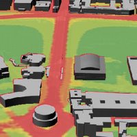
Blogsite Cartography has an interesting feature on a London 3D map that displays degrees of air pollution:
"The London Air Quality Network has an interactive map that displays the prevalence of various air pollutants. The map is pannable and zoomable (using the overview map) and clicking on triangular portions of the map will produce a 3 dimensional view of the area with the selected pollutant draped over the landscape, giving a flooded look to the scene. A timeline bar at the bottom of the map extends from 2003 to 2010 and gives the impression that pollutants are being (or will be) reduced.
By way of Digitally Distributed Environments who have a 3-dimensional surface video of some of the data."
The world's first internet phone system in a city
A BBC Online article titled 'Taipei to embrace net telephones' discusses how Taipei is soon to become a world first - a whole city using an Internet phone system:
"Some mobiles can switch between wi-fi and the phone network
The city of Taipei, in Taiwan, could have 200,000 people making phone calls using wi-fi by the end of 2006.Ten companies are pushing a "Taipei Easy Call" initiative which involves mobiles which can switch between calls using wi-fi and the phone network.
"If this is successful, then the model could be copied in cities elsewhere in the world," said Daniel Wongg, of the Taipei Computer Association.
The wi-fi mobiles provide a cheaper alternative to mobile phone calls.
"This is the world's first internet phone system using the whole city, rather than a spot, as a wireless operation environment," Mr Wongg told AFP news agency.
The initiative also involves switching schools and government offices from the traditional phone network to one using internet phones, known as Voice over Internet Protocol (Voip)."
Soon for the UK??
"Some mobiles can switch between wi-fi and the phone network
The city of Taipei, in Taiwan, could have 200,000 people making phone calls using wi-fi by the end of 2006.Ten companies are pushing a "Taipei Easy Call" initiative which involves mobiles which can switch between calls using wi-fi and the phone network.
"If this is successful, then the model could be copied in cities elsewhere in the world," said Daniel Wongg, of the Taipei Computer Association.
The wi-fi mobiles provide a cheaper alternative to mobile phone calls.
"This is the world's first internet phone system using the whole city, rather than a spot, as a wireless operation environment," Mr Wongg told AFP news agency.
The initiative also involves switching schools and government offices from the traditional phone network to one using internet phones, known as Voice over Internet Protocol (Voip)."
Soon for the UK??
Wednesday, July 05, 2006
Safety Camera Database
PocketGPSWorld.com has just updated its Safety Camera Database:
"The PocketGPSWorld Speed Camera Database has just been updated there are a total of 9211 cameras in the database. 3555 Gatso, 4200 Mobiles, 62 Temporary, 153 Specs, 248 Truvelo, and 979 Redlight Cameras.
We have had a total of 133 verified static cameras added this month submitted by 96 members. All members submitting the first report of these static cameras have been credited with lifetime memberships. We have processed an astonishing 3087 changes in the database this month, 2000 of them in the last week. This is why the release is a little late, we wanted to ensure that we were as up to date as possible."
If you go to the site you can get the RSS feed that updates you automatically when the database is updated!
"The PocketGPSWorld Speed Camera Database has just been updated there are a total of 9211 cameras in the database. 3555 Gatso, 4200 Mobiles, 62 Temporary, 153 Specs, 248 Truvelo, and 979 Redlight Cameras.
We have had a total of 133 verified static cameras added this month submitted by 96 members. All members submitting the first report of these static cameras have been credited with lifetime memberships. We have processed an astonishing 3087 changes in the database this month, 2000 of them in the last week. This is why the release is a little late, we wanted to ensure that we were as up to date as possible."
If you go to the site you can get the RSS feed that updates you automatically when the database is updated!
Animated Flight Atlas
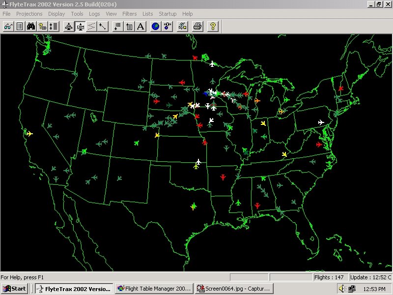
A post of interest to mapping/visualising flight paths - from Cartography:
"Michael Peterson presented his flight atlas at last week’s Geotec / CCA conference. The atlas is collection of animated maps that show the movement of commercial aircraft across the United States and Canada in a 24 hour time span. The atlas is not available online - the 3.4 GB of animation makes that difficult to do - but it does have a website where some of its features are highlighted. Included is a sample animation (avi format, 13.2 MB; you might need to download the latest DivX codec for it to play properly) showing flights in and out of Atlanta. Data for the project was collected using the FlyteTrax program from FlyteComm. Users can select aircraft by type, airport or airline. A great tool for seeing air traffic patterns.
Interactive subway maps
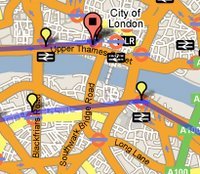
Two new interactive subway maps using Google Maps have been set-up. These maps are more functional than the pan and zoom maps - here the user can select an origin, a destination and a time and a route will be mapped out, along with the estimated time of travel. Currently maps exist for New York and London.
Via Cartography
Tuesday, July 04, 2006
Air-travel to tripple?
BBCNews has a piece titled 'Euro MPs debate air travel impact' in which they discuss limiting the impacts of air-travel:
"The UK predicts air travel will triple in the next 30 years.
The EU executive, the European Commission, is currently preparing legislation to reduce greenhouse gases from aviation.
The European Parliament is discussing the proposals, contained in a report, as Europeans queue up at airports to fly off on holiday.
The report recommends that the airline industry's exemption from paying Value Added Tax (VAT) on fuel should be scrapped, and says an additional fuel tax should be brought in. It would apply around the world."
Someone has to pay...
"The UK predicts air travel will triple in the next 30 years.
The EU executive, the European Commission, is currently preparing legislation to reduce greenhouse gases from aviation.
The European Parliament is discussing the proposals, contained in a report, as Europeans queue up at airports to fly off on holiday.
The report recommends that the airline industry's exemption from paying Value Added Tax (VAT) on fuel should be scrapped, and says an additional fuel tax should be brought in. It would apply around the world."
Someone has to pay...
A driverless drive
The Daily Mail has, in this instance, an interesting article titled 'The self-driving Golf that would give Herbie a run for its money' that talks about a smart driverless car from VW.... it says:
"But now German car giant Volkswagen has turned fiction into reality by unveiling a fully automatic car which really can drive itself - and at speeds of up to 150mph.
It can weave with tyres screeching around tricky bends and chicanes, and through tightly coned off tracks - without any help or intervention from a human...
...The GTi has electronic 'eyes' that use radar and laser sensors in the grille to 'read' the road and send the details back to its computer brain. A sat-nav system tracks its exact position with pin-point precision to within an inch.
The car can then work out the twists and turns it has to negotiate - before setting off at break-neck speed through a laid out course on a test track.
On a race circuit, it drove itself faster and more precisely than the VW engineers could manage - and can accelerate independently up to its top speed of 150mph."
Is this the beginning of the end of the driver?
"But now German car giant Volkswagen has turned fiction into reality by unveiling a fully automatic car which really can drive itself - and at speeds of up to 150mph.
It can weave with tyres screeching around tricky bends and chicanes, and through tightly coned off tracks - without any help or intervention from a human...
...The GTi has electronic 'eyes' that use radar and laser sensors in the grille to 'read' the road and send the details back to its computer brain. A sat-nav system tracks its exact position with pin-point precision to within an inch.
The car can then work out the twists and turns it has to negotiate - before setting off at break-neck speed through a laid out course on a test track.
On a race circuit, it drove itself faster and more precisely than the VW engineers could manage - and can accelerate independently up to its top speed of 150mph."
Is this the beginning of the end of the driver?
Who's Reviving the Electric Car?
It appears that electric cars are getting more attention recently - is it because people are demanding more eco-friendly forms of transport?... the rising cost of fuel?... or new tech-ventures are soon to be launching their electric car models on the market? Or a hybrid of them all? Here is what Worldchanging is saying:
"Several notable efforts are taking place to bring all-electric or plug-in hybrid-electric vehicles to market. And for all appearances, these stand to be far more substantive -- and more sustainable -- than GM's initial entry ever was.
Over the past few months, I've been tracking several threads of this story. Here's a snapshot of what's going on.
At least two car makers are viewing electric cars as a high-end niche market -- something the Hollywood or well-heeled Silicon Valley set will want to embrace simply for the cool factor. After all, now that "everyone" has a Prius, what's the Next Green Thing?
The Tesla, for starters. Tesla Motors, a Silicon Valley start-up, has been keeping its sports car under tight wraps for months, showing it only to a privileged few. (I assumed that my role on the clean-tech advisory council of VantagePoint Venture Partners, the venture capital firm that is the lead institutional investor in Tesla, would get me in the door to have an early look. It didn't.) Tesla's first vehicle, an electric sports car set to be unveiled later this month, runs on the same lithium-ion batteries found in cameras and cell phones -- 7,000 of them per vehicle, the inventors told me. They claim that the Tesla Roadster, built on the chassis of a Lotus Elise, will go from 0 to 60 mph in just four seconds, travel 250 miles before needing to be recharged (by plugging in to a regular AC outlet), and retail for about $80,000. They intend that Tesla's second-generation car, due out in 18-24 months, will be somewhat more popularly priced at around $50,000.
The Tesla rolls in the same league as the Wrightspeed, another Silicon Valley entrant. (Founder Ian Wright formerly worked at Tesla.) Wrightspeed's X1 model is a high-performance all-electric $120,000 roadster that beat out a $440,000 Porsche on a test track. (I did manage to snag a ride on the X1. Wright took me for a spin in downtown Palo Alto late one night, showing off his car's prowess by going from 0 to 80 to 0 in a single city block. It was the closest I can approximate to being shot out of a cannon -- albeit a noiseless cannon, but for the wind racing by.) The X1, which is not yet in production, boasts a quarter ton of rechargeable batteries."
Read more here
"Several notable efforts are taking place to bring all-electric or plug-in hybrid-electric vehicles to market. And for all appearances, these stand to be far more substantive -- and more sustainable -- than GM's initial entry ever was.
Over the past few months, I've been tracking several threads of this story. Here's a snapshot of what's going on.
At least two car makers are viewing electric cars as a high-end niche market -- something the Hollywood or well-heeled Silicon Valley set will want to embrace simply for the cool factor. After all, now that "everyone" has a Prius, what's the Next Green Thing?
The Tesla, for starters. Tesla Motors, a Silicon Valley start-up, has been keeping its sports car under tight wraps for months, showing it only to a privileged few. (I assumed that my role on the clean-tech advisory council of VantagePoint Venture Partners, the venture capital firm that is the lead institutional investor in Tesla, would get me in the door to have an early look. It didn't.) Tesla's first vehicle, an electric sports car set to be unveiled later this month, runs on the same lithium-ion batteries found in cameras and cell phones -- 7,000 of them per vehicle, the inventors told me. They claim that the Tesla Roadster, built on the chassis of a Lotus Elise, will go from 0 to 60 mph in just four seconds, travel 250 miles before needing to be recharged (by plugging in to a regular AC outlet), and retail for about $80,000. They intend that Tesla's second-generation car, due out in 18-24 months, will be somewhat more popularly priced at around $50,000.
The Tesla rolls in the same league as the Wrightspeed, another Silicon Valley entrant. (Founder Ian Wright formerly worked at Tesla.) Wrightspeed's X1 model is a high-performance all-electric $120,000 roadster that beat out a $440,000 Porsche on a test track. (I did manage to snag a ride on the X1. Wright took me for a spin in downtown Palo Alto late one night, showing off his car's prowess by going from 0 to 80 to 0 in a single city block. It was the closest I can approximate to being shot out of a cannon -- albeit a noiseless cannon, but for the wind racing by.) The X1, which is not yet in production, boasts a quarter ton of rechargeable batteries."
Read more here
Digital Planet July 4 2006
On Digital Planet this week -
"Gareth Mitchell hears from Rio de Janeiro how Microsoft now include a Creative Commons license for documents and how the same scheme can get you a free beer. Clark Boyd reports from a conference in New York on ?persuasive gaming? - video games that teach about global conflict. There?s news of a system ? tex2me ? that cuts the cost of text messaging almost to zero. And we visit the store that never sleeps ? the little apple in the Big Apple."
Listen here
"Gareth Mitchell hears from Rio de Janeiro how Microsoft now include a Creative Commons license for documents and how the same scheme can get you a free beer. Clark Boyd reports from a conference in New York on ?persuasive gaming? - video games that teach about global conflict. There?s news of a system ? tex2me ? that cuts the cost of text messaging almost to zero. And we visit the store that never sleeps ? the little apple in the Big Apple."
Listen here
Thursday, June 29, 2006
The Future of the Car
This special online edition of Popular Science titled 'The Future of the Car':
"We have reached an odd, maybe unique point in the history of technology, when the distant future is easier to imagine than the more proximate months and years ahead. Fifty years from now, most parties would agree, hydrogen fuel cell technology will power our world—everything from artificial organs to cruise ships and certainly our automobiles. By then we will have figured out how to produce cheap, CO2-neutral hydrogen—perhaps by using renewable energy sources such as wind and solar power to electrolyze water, perhaps with synthetic fuels (bio-ethanol and bio-diesel), perhaps by sequestering carbon from fossil feed stocks such as coal, perhaps with some fairy dust as yet undiscovered. By then the fuel cell industry will be sufficiently advanced to build very compact hydrogen tanks with enormous energy density, and fuel cells that are cheap enough for economy cars and robust enough for chilly northern climates—assuming global warming hasn’t already taken care of that problem for us..
...The automobile will at last fulfill the promise resonant in the words “autonomous mobility.” Mass transit as we think of it now will seem as wrongheaded as eugenics. Automobiles’ quantum-computer cores will be the archives of our memory, our machine adjuncts, our confidantes, in ways so profound and personal as to mock today’s limited PDA phones. We will have merged with our cars."
Other articles on the future of the automobile available here
"We have reached an odd, maybe unique point in the history of technology, when the distant future is easier to imagine than the more proximate months and years ahead. Fifty years from now, most parties would agree, hydrogen fuel cell technology will power our world—everything from artificial organs to cruise ships and certainly our automobiles. By then we will have figured out how to produce cheap, CO2-neutral hydrogen—perhaps by using renewable energy sources such as wind and solar power to electrolyze water, perhaps with synthetic fuels (bio-ethanol and bio-diesel), perhaps by sequestering carbon from fossil feed stocks such as coal, perhaps with some fairy dust as yet undiscovered. By then the fuel cell industry will be sufficiently advanced to build very compact hydrogen tanks with enormous energy density, and fuel cells that are cheap enough for economy cars and robust enough for chilly northern climates—assuming global warming hasn’t already taken care of that problem for us..
...The automobile will at last fulfill the promise resonant in the words “autonomous mobility.” Mass transit as we think of it now will seem as wrongheaded as eugenics. Automobiles’ quantum-computer cores will be the archives of our memory, our machine adjuncts, our confidantes, in ways so profound and personal as to mock today’s limited PDA phones. We will have merged with our cars."
Other articles on the future of the automobile available here
Wednesday, June 28, 2006
Mapping the Blogosphere
Just learned that The Chronicle of Higher Education has a short story, accompanied with an audio-visual presentation, on mapping the blogosphere. The story relates to a posting on the blog Data Mining which has posted a couple of maps of the blogosphere. The approach he takes is that those blogs that are more popular (i.e. are linked to more often) will be closer to the core.
Thanks to Cartography
Thanks to Cartography
Mobilities, Networks, Geographies
An interesting book just published titled 'Mobilities, Networks, Geographies' from Jonas Larsen, John Urry and Kay Axhausen:
The last decade or so has seen striking increases in both long-distance travel and in communications through mobile phones, text messaging, emailing, videoconferencing and so on. Such developments in communication, along with a similar increase in physical travel and movement of goods around the globe, reconfigure social networks by disconnecting and reconnecting people in new ways. This book puts forward one of the first social science studies of the geographies of social networks and related mobilities of travel, communications and face-to-face meetings. The book examines five interdependent mobilities that form and reform these geographies of networks and travel in the contemporary world. These are: physical travel of people for work, leisure, pleasure, migration and escape; physical movement of objects delivered to producers, consumers and retailers; imaginative travel elsewhere through images and memories seen on texts, TV, computer screens and film; virtual travel on the internet; and communicative travel through letters, cards, telegrams, telephones, faxes, text messages and videoconferences. In the book the authors examine the interconnections between these different mobilities. They research how travel and social meetings require systems of coordination using virtual and communicative travel in-between physical travel and meetings. They argue that, while it might be imagined that there would be less need of physical meetings with improved ICTs, on the contrary, scheduled visits and meetings have become highly significant. The research shows that they are necessary to social life in the contemporary world, both within business and especially within families and friendships which are increasingly conducted at-a-distance.
The last decade or so has seen striking increases in both long-distance travel and in communications through mobile phones, text messaging, emailing, videoconferencing and so on. Such developments in communication, along with a similar increase in physical travel and movement of goods around the globe, reconfigure social networks by disconnecting and reconnecting people in new ways. This book puts forward one of the first social science studies of the geographies of social networks and related mobilities of travel, communications and face-to-face meetings. The book examines five interdependent mobilities that form and reform these geographies of networks and travel in the contemporary world. These are: physical travel of people for work, leisure, pleasure, migration and escape; physical movement of objects delivered to producers, consumers and retailers; imaginative travel elsewhere through images and memories seen on texts, TV, computer screens and film; virtual travel on the internet; and communicative travel through letters, cards, telegrams, telephones, faxes, text messages and videoconferences. In the book the authors examine the interconnections between these different mobilities. They research how travel and social meetings require systems of coordination using virtual and communicative travel in-between physical travel and meetings. They argue that, while it might be imagined that there would be less need of physical meetings with improved ICTs, on the contrary, scheduled visits and meetings have become highly significant. The research shows that they are necessary to social life in the contemporary world, both within business and especially within families and friendships which are increasingly conducted at-a-distance.
Subscribe to:
Posts (Atom)