Blogsite Cartography has an interesting feature on a London 3D map that displays degrees of air pollution:
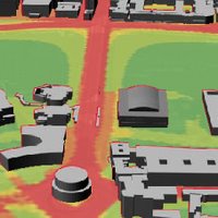
"The London Air Quality Network has an interactive map that displays the prevalence of various air pollutants. The map is pannable and zoomable (using the overview map) and clicking on triangular portions of the map will produce a 3 dimensional view of the area with the selected pollutant draped over the landscape, giving a flooded look to the scene. A timeline bar at the bottom of the map extends from 2003 to 2010 and gives the impression that pollutants are being (or will be) reduced.
By way of Digitally Distributed Environments who have a 3-dimensional surface video of some of the data."
No comments:
Post a Comment