The Centre for Mobilties Research (CeMoRe) studies and researches the newly emerging interdisciplinary field of 'mobilities': the large-scale movements of people, objects, capital, and information across the world.
Thursday, November 23, 2006
Mobiles hope to be 'smart wallet'
'NFC is a short-range wireless technology like RFID tags, which are used to track stock by retailers. The tags inside phones could have personal information stored in them and so could act as car keys, money, tickets and travel cards. Mobile firms representing 40% of the global mobile market back NFC.Alex Sinclair, chief technology officer of the GSM Association, which represents the mobile industry, said: "Interoperability and standardisation are the fundamental requirements for mobile market success.
"NFC opens up a wide range of possibilities and we are committed to ensuring the mobile industry works together to realise its potential."'
Surveillance cameras that listen
'Revellers planning a night out in the Netherlands this weekend should keep their voices down.
To prevent fights breaking out, surveillance cameras in the city of Groningen have been adapted to listen out for voices raised in anger. Microphones attached to the cameras feed the sound signals to software that can detect voices that are aggressive in tone. "Aggressive people tend to tense their larynx, and the sound made by their vocal cords is distorted," says Peter van Hengel of developer Sound Intelligence, a spin-off of the University of Groningen. This means that high frequency vowel sounds span a broader frequency range. "A truly aggressive voice is very hard to imitate," he says.'
What senses are next, one wonders??
Monday, November 20, 2006
The way to work: Space, place and technology in 2016
'Businesses must prioritise managing intellectual property and flexibility of work time and location to control organisational change over the next 10 years, according to the latest report from the Orange Future Enterprise coalition (OFEc). “The way to work: space, place and technology in 2016” sets out the challenges to business of the future in light of evolving social, economic, political and organisational pressures.'
Download:
'The way to work in 2016: Space, place and technology in 2016' OFEc report (1.53 Mb, pdf)
'The way to work in 2016: Space, place and technology in 2016' Podcast (6 Mb, mp3)
Hyperlinking Reality via Phones
'A Nokia research project could one day make it easier to navigate the real world by superimposing virtual information on an image of your surroundings. The new software, called Mobile Augmented Reality Applications (MARA), is designed to identify objects viewed on the screen of a camera phone.
The Nokia research team has demonstrated a prototype phone equipped with MARA software and the appropriate hardware: a global positioning system (GPS), an accelerometer, and a compass. The souped-up phone is able to identify restaurants, hotels, and landmarks and provide Web links and basic information about these objects on the phone's screen.'
Dail and Park in Paris
'A service starting in Paris next month is designed to make life somewhat easier for harried drivers by allowing them to find out, in real time, whether there are parking spaces available nearby by using their cellphones or GPS navigation devices.
The system will monitor the status of about 120 public parking garages across the French capital. From their phones, drivers will be able to find out whether a nearby garage is open and has places available.
"At certain times of day, 20 to 25 percent of vehicles are in search of a parking space. With this service, we should be able to improve the traffic flow," said François Le Vert, a representative of the Fédération Nationale des Métiers du Stationnement, an organization of French parking institutions that helped develop the system.'
Via Smartmobs
Biodiesel Fueling Location Information for Cell Phones and Mobile Devices
'NearBio, operated and invented by WHDC LLC, a privately held company specializing in distributed mobile applications, has introduced a service that enables mobile phone users (and computer users) to find the nearest biodiesel fueling locations based on city, zip code, or GPS coordinates.
The national database of more than 1,000 individually verified locations is updated daily and is complete with driving directions, hours, payment options, and blend information (where available). The website’s graphical map of nationwide locations is the first of its kind, using a color-coded icon for each pump location to identify the specific blend available.'
Plain Air Dining
'I hate parking lots. I hate their pervasiveness; I hate how, in this driver-friendly era, we’ve forgotten to relegate them behind buildings. I hate the flat, empty space they create. Recently we’ve begun landscaping them, as if we know it’s bad to cover so much ground with cement for our cars. To make amends, we build little green islands in the hard, gray seas, then anchor our cars next to them. It reminds me of the way farmers leave a wild copse in the middle of a field as a wildlife refuge. Only, in the case of the parking lot, it seems we’re both the farmer and the rabbit running from the fox. Have you noticed? The first spaces to be taken are always the ones in the shade.'
Saturday, November 18, 2006
New Fuels for new mobilities
Firstly, there is the new BMW just showcased - a hybrid hydrogen vehicle. It is discussed in this BBC article where both the pros and cons are outlined. Of course, its both expensive and there are currently only 5 refueling stations in the world that are compatible with the BMW technology - so plan that trip carefully!
Secondly, a fascinating account from ScienceDaily called Microorganisms One Part Of The Solution To Energy Problem which says that the answer to one of the world's largest problems -- the need for clean, renewable sources of energy -- might just come from some of the world's smallest inhabitants -- bacteria!
A new report published on this - Microbial Energy Conversion - can be downloaded from here
Latest in GPS vehicle tracking
Mobile security in the 21st century?
'Six months ago, with the help of a rather scary computer expert, I deconstructed the life of an airline passenger simply by using information garnered from a boarding-pass stub he had thrown into a dustbin on the Heathrow Express. By using his British Airways frequent-flyer number and buying a ticket in his name on the airline's website, we were able to access his personal data, passport number, date of birth and nationality. Based on this information, using publicly available databases, we found out where he lived, his profession, all his academic qualifications and even how much his house was worth.
It would have been only a short hop to stealing his identity, committing fraud in his name and generally ruining his life.'
Mobile security in the 21st century?
Wednesday, November 15, 2006
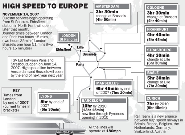
New High Speed Train Networks

Is the future more about mass high-speed train transport than individualised motor vehicle travel? Yesterday saw the completion - finally - of the Channel Tunnel Rail Link, which has been renamed High Speed 1 (or HS1). This new link will 'allow Eurostar trains to accelerate to 186mph (300km/h) within minutes of leaving their new terminus at St Pancras. They will reach the Channel Tunnel 70 miles away in half an hour, shaving about 25 minutes off the journey time to Paris and Brussels. London to Paris will take 2 hours and 15 minutes'
According to The Times in Travel times slashed as London gets on the fast track to Europe :
Eurostar is joining forces with high-speed rail operators in six European countries to offer through tickets and fast connections. Journey times from London to Amsterdam, Cologne, Strasbourg and Zurich will be cut by up to two hours, making rail a fast alternative to air travel for the first time in 30 years.From November 14 next year Eurostar passengers will no longer have to spend the first 30 miles of their journey on slow, suburban lines in South London.
A Report on the Surveillance Society
This study had been commissioned by the Information Commissioner and was undertaken by the Surveillance Studies Network, with the principal report authors having connection to the academic organisation/journal Surveillance & Society.
This 100 page report is now available in full here.
Enjoy!
Tuesday, November 14, 2006
Transology: Reinventing The Wheel
Worth a look... especially for re-conceptualising urban mobilities
When Maps Reflected Romance of the Road
'Perhaps it is the contrast with digital maps that makes old-fashioned paper road maps seem rich and wonderful again. Those colorful guides once found in every glove compartment are gaining desirability not just as collectibles but as cultural records — even in archives as august as those of the Library of Congress....
...The old road maps don’t give oral directions or find the nearest A.T.M. But their resolution, design and colors all make the digital variety pale: the screens in our cars seem like remnants of the days of the first I.B.M. PCs...In the ’20s, maps also often showed airplanes, boats and other exciting vehicles that used the fuel and oil produced by the company issuing the map.'Thanks to Mimi!
New generation of location-based services
'The results could mark a coming of age for converging communications and positioning technologies.
LIAISON is one of the largest current initiatives to develop and implement a new generation of location-based services (LBS) for the professional market. The project approach, based on what is called 'enhanced assisted GPS', is designed to improve the speed, accuracy and reliability of existing GPS systems, allowing a whole new range of time, cost and life-saving services to be developed.
The three-and-a-half year initiative involves more than 30 partners from 10 European countries and, after an extensive test programme commencing in November 2006, should result in several commercial systems. Some applications are likely to be on the market before the project ends in April 2008.
“We expect to be able to start commercialising within months of the different trials concluding successfully,” explains LIAISON coordinator Rémi Challamel of Alcatel Space in France.'
Monday, November 13, 2006
Running Stitch - capturing space...
Running Stitch is being described as 'A tapestry map, created live, using satellite navigation' by artists Jen Southern & Jen Hamilton
The Cosmobilities Network
This is a site/place always worth checking out as they have interesting links/articles on mobilities studies.
Also worth checking out is the exellcent slide show from the recent AIR TIME-SPACES: NEW METHODS FOR RESEARCHING MOBILITIES event that took place at Lancaster University, September 29-30 2006.
The photo-slideshow can be seen here
Note: the next cosmobilities meeting from September 7 - 8 in 2007 in Basle/Switzerland. The theme is 'Mobilities, Space and Inequality'.
For more information, check the newsletter, the cosmobilities website or visit the conference website
Interface for mobile-music on the Underground
'undersound is a new type of experience, an interface that is on your mobile phone and in the underground stations you pass through every day. It is part personal, part public and all about the tube. undersound is a way of listening to, distributing and affecting the flow of music in the underground that goes beyond just the music itself. It allows you to see your journeys, the people around you, and the tube itself in a new light. There are three key aspects of life underground that we tapped into in the design of undersound.'
undersound will be spatially distributed at individual stations and throughout the wider tube network. I can add music to the system at upload points in the ticket halls , and I can download tracks on the platforms. Architectural configuration of the stations affects my experience of contributing and downloading music as the proximal nature of the interaction with these situated points require s myself and other undersound users to congregate at certain locations within the station for the purpose of interacting with the system.
Via Smartmobs
Thursday, November 02, 2006
Robotising Military Mobilities
'The Army is pushing for a three-phase combat robot development project to build three types of robots for use in combat situations, in cooperation with the state-run Agency for Defense Development (ADD) and other private industrial counterparts, such as the Korea Advanced Institute of Science and Technology (KAIST).
...All information on situations on the battlefield, including the number of casualties, soldiers’ locations, kinds of weapons systems being used by enemy forces and lethality of specific weapons, are transmitted to the command-and-control center on a real-time basis through laser transmitters attached to soldiers and weapons systems.'
Where will all the soldiers go??
Britain has sleepwalked into pervasive surveillance
The report also stresses that dataveillance has increased drastically, as well as a future of targeted branding. This also includes satellite tracking of all future journeys and the introduction of individually customised payments, as well as job and school screening. This is the first report to really highlight the immediacy of this situation...and it sounds uncomfortable.
You can read separate accounts of this report from the BBC, Guardian, and The Times respectively:
Britain is 'surveillance society'
Spy planes, clothes scanners and secret cameras: Britain's surveillance future
By 2016, they'll be able to watch you everywhere
Also, of interest, is an article by Steve Wright called The ECHELON Trail: An Illegal Vision in which he describes how as an academic researcher at Lancaster University in the UK (thats us!) - he was investigating the Echelon surveillance system and was harrassed by Special Forces who came to his home and forced him to go with them to the university with the aim of confiscating his research... we researchers at Lancaster have a reputation, it seems...